Accessibility

MOBILITY PRIORITIES

This image depicts a map of the Syracuse University Campus titled “Proposed Pedestrian Circulation.” Bound at the top by Harrison Street and at the bottom by Oakwood Cemetery, leftmost is Henry Street and Thornden Park to the right. SU’s Shaw Quadrangle is at the center of the image. Icons depicting housing and the University Neighborhood populate the boundaries of the image on all sides, including housing along Waverly Avenue, Ostrom Avenue, the neighborhood along Euclid Avenue, Mount Olympus and West Campus. A distinct point at the center of the Quad is connected to an arrow spanning the distance of one-quarter mile to scale, and is labeled '5 minutes, quarter mile.' Many pathways are highlighted in orange on this map, and are described by the key as a broad line signifying a path of major pedestrian circulation, a narrow line signifying a path of secondary circulation and a dotted line signifying major internal pedestrian circulation. Major pedestrian circulation occurs on the proposed Academic Promenade reaching from Henry Street, along the north side of the Dome, and stopping at the College Place Bus Hub, the University Place Promenade connecting across from Irving Avenue to Ostrom Avenue, and the proposed Waverly Avenue Promenade from Waverly Avenue to Ostrom Avenue. Major pedestrian circulation is also depicted from the Quad reaching north along University Avenue and from Waverly Avenue south to College Place until heading east along Euclid Avenue. Major internal pedestrian circulation through buildings is depicted between the University Place Promenade and the Waverly Avenue Promenade from the south entrance of the Schine Student Center heading northwest, from the south to the north of Bird Library, and from the south to the northeast of Watson Hall. Internal pedestrian circulation is also depicted through the proposed Dome and The Arch complex along what is now an open lane between the Carrier Dome and Archbold Gymnasium. Many other campus pathways and surrounding streets are highlighted in orange as secondary pedestrian circulation routes. An accessible PDF is available below, as is a description of the map in Accessibility-Map-Description.docx.
The Campus Framework emphasizes mobility improvements for pedestrian, bicycle, and transit systems to encourage sustainable mobility practices campus-wide.

UNIVERSAL DESIGN

Proposed initiatives improve mobility by incorporating universal design in new projects and retrofitting historic structures to improve accessibility. Accessibility is an issue that will be addressed beyond mobility, and future landscape and building projects will seek to overcome accessibility challenges.

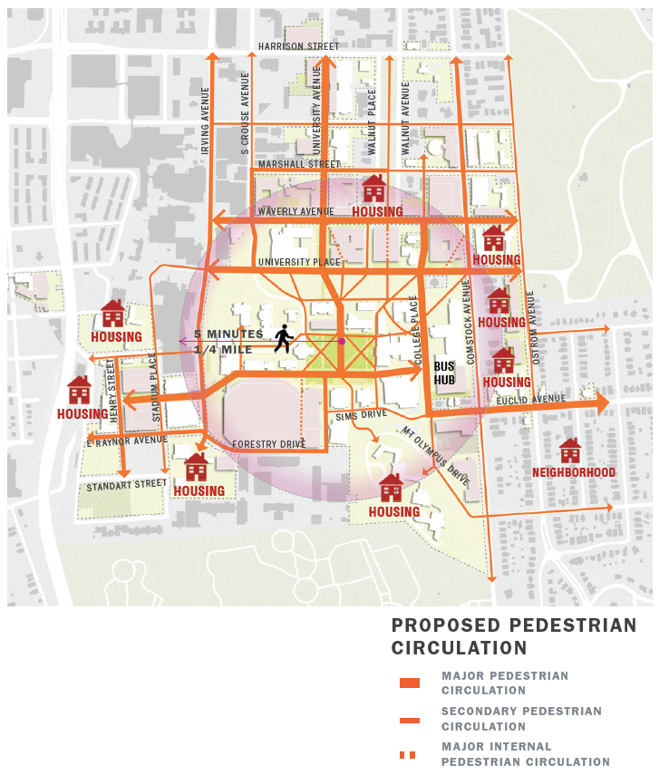
PEDESTRIAN CIRCULATION

A more walkable, compact campus simultaneously reduces emissions and promotes exercise. Improved pedestrian circulation will encourage more people to embrace walking between campus destinations. Signage, wayfinding, and streetscape elements will significantly improve the pedestrian experience.

BICYCLE NETWORK

Development of a unified system of bicycle paths, routes, and lanes that establish clear protocols for bicycle and vehicular traffic will encourage more people to safely and comfortably embrace biking.

TRANSIT SYSTEM

Revised transit loops, schedules, and improved wayfinding and digital updates will enhance service, improve rider experience, and reduce University costs.

VEHICULAR NETWORK AND PARKING STRATEGY

With development of a more compact campus, parking will be located in garages at the campus periphery. Additional lots on South Campus will provide remote parking for long-term needs.

[Mobility-Priorities] [Map-Description.docx]